Key Highlights:
- Geographic Spot: Las Vegas is located in the southern tip of Nevada within the Mojave Desert (Clark County).
- The Coordinates: It sits at approximately 36.17° N, 115.14° W at an elevation of roughly 2,000 feet.
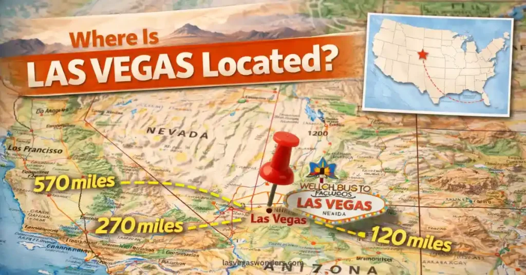
- Major Proximity: It is about 270 miles northeast of Los Angeles and 300 miles southwest of Salt Lake City.
- The “Strip” Secret: Interestingly, the famous Las Vegas Strip is actually located just outside the city limits in an unincorporated township called Paradise.
Whether you are planning a desert road trip or hopping on a flight across the country, knowing exactly where Las Vegas is located involves more than just a spot on a map. While most people think of it as a standalone oasis of neon, it is actually the crown jewel of the Mojave Desert, nestled in a valley surrounded by stunning mountain ranges.
We have spent years navigating the highways that lead to the Strip and exploring the rugged terrain that borders the city. Understanding its geography is the first step to planning your logistics, whether you’re coming from Los Angeles or overseas. Here is our honest, “trusted friend” guide to the location and surrounding landscape of Sin City.
Where Is Las Vegas Located on the Map?
If you look at a map of the United States, you will find Las Vegas in the southwestern corner of Nevada. It sits in Clark County, which is home to nearly three-quarters of the state’s residents.
The city is situated in an arid basin on the desert floor, ringed by mountain ranges that turn pink and purple during the sunset. To the west, you have the towering Red Rock Canyon and Mount Charleston (the highest peak in the Spring Mountains), and to the east, the gateway to Lake Mead and the Hoover Dam.
Direct Answer: Las Vegas is located in the Mojave Desert in Southern Nevada. It sits approximately 2,000 feet above sea level and is surrounded by the Spring Mountain Range to the west and the Muddy Mountains to the northeast, with the Colorado River located roughly 30 miles to the east.
How Far Is Las Vegas from Major Cities?
One of the most common questions we have heard is about travel times. Because it’s a massive hub, Las Vegas is surprisingly accessible from other western landmarks, making it a perfect anchor for a multi-city vacation.
- Los Angeles, CA: ~270 miles (4 to 5 hours driving via I-15).
- Phoenix, AZ: ~300 miles (4.5 to 5 hours driving via US-93).
- Grand Canyon (South Rim): ~280 miles (4.5 hours driving).
- Salt Lake City, UT: ~420 miles (6 hours driving via I-15).
Direct Answer: To reach Las Vegas from Los Angeles, most travelers drive northeast on Interstate 15 for about four to five hours. For those flying, Harry Reid International Airport (LAS) is located just two miles from the Strip, making it one of the most conveniently located airports in the world.
Also Read: How Far Is Las Vegas Strip From the Airport?
Understanding the “Strip” vs. “Downtown” Locations
When people ask where is Las Vegas located, they are usually thinking of the casinos. However, the geographic reality is a bit more technical.
The Las Vegas Strip (Paradise, NV)
The 4.2-mile stretch of Las Vegas Boulevard that houses the Bellagio, Caesars Palace, and the Sphere is technically not in the City of Las Vegas. It is in an unincorporated area called Paradise. This was originally done so the big casinos could avoid certain city taxes, and the name stuck!
Downtown Las Vegas (Fremont Street)
This is the “official” City of Las Vegas. Located about 15 minutes north of the Strip, this is where the city began. It has a much more “urban” feel with traditional city blocks, government buildings, and the famous vintage neon of the Fremont Street Experience.
Also Read: What Is The Difference Between Staying On The Strip Versus Downtown Las Vegas?
The Natural Landscape Surrounding the City
Las Vegas isn’t just a concrete jungle; its location makes it a “base camp” for some of the best outdoor activities in the country.
- Red Rock Canyon: Located about 15 miles west. It offers a 13-mile scenic drive and world-class rock climbing.
- Valley of Fire State Park: Located about 50 miles northeast. This features red sandstone formations that look like they belong on Mars.
- Mount Charleston: Located about 45 minutes northwest. In the winter, you can actually ski here, and in the summer, the temperature is usually 20 to 30 degrees cooler than on the Strip.
Summary & Final Pro Tip
Knowing where is Las Vegas located helps you realize it is a central hub for the entire Southwest, not just a place to gamble.
Our Best Pro Tip: If you are driving in from Los Angeles on a Friday or leaving on a Sunday afternoon, be prepared for the “Vegas Crawl.” That 4-hour drive can easily turn into 8 hours. If you can, travel on “off” days like Thursday or Monday to have the highway to yourself.
❓ FAQ: Where Is Las Vegas Located?
Is Las Vegas close to the Grand Canyon?
Grand Canyon West is about a 2-hour drive. The South Rim (the most famous park area) is about a 4.5-hour drive.
What time zone is Las Vegas in?
Las Vegas is in the Pacific Time Zone (PT). It is usually 3 hours behind New York and the same time as Los Angeles.
Is it always hot in Las Vegas?
No. Because of its location in the high desert, it gets quite chilly. While summer days hit 105°F+, December and January nights frequently drop to the 30s.
Keep Reading:
- What Is Las Vegas Known For? The Real Reasons People Love Vegas
- How to Choose the Best Las Vegas Travel Package?
- How to Plan a Trip to Las Vegas: Easy Step-by-Step Guide
- Las Vegas Expert FAQs: 100 Answers to Plan Your Perfect Trip
- Is Las Vegas Worth Visiting? Full Travel Verdict
- Best Area to Stay in Las Vegas for First Timers