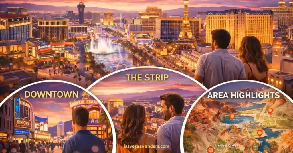
Key Highlights:
- The Strip (South): The iconic 4.2-mile stretch of Las Vegas Blvd where the famous mega-resorts (Bellagio, Caesars, MGM) live.
- Downtown (North): Located about 4 miles north of the Strip; home to “Old Vegas,” Fremont Street, and the Arts District.
- The Connection: Use the Deuce Bus or Rideshare to travel between the two. Do not try to walk from the Strip to Downtown—it’s too far and the pedestrian infrastructure is spotty.
- Pro Tip: Download an offline map. Wi-Fi inside massive casinos is notoriously flaky, and you don’t want to lose your signal near Allegiant Stadium.
Las Vegas is a city that can easily overwhelm you if you don’t have a plan. Between the four-mile stretch of the Strip and the historic neon of Downtown, there is a massive amount of ground to cover. Most first-timers underestimate the scale of these “mega-resorts”—what looks like a five-minute stroll on a screen can easily turn into a thirty-minute trek in the desert sun.
We have navigated every shortcut and tram route in the valley, and we can tell you: a good map is your best friend. From finding the free trams to knowing where the Arts District actually begins, here is our honest, expert-led Las Vegas Map Guide.
Las Vegas Area Quick Reference
Understanding the distinct zones will help you pick the right home base for your trip.
| Area | Vibe | Best For | Key Landmarks |
|---|---|---|---|
| South Strip | Iconic & Grand | First-timers | Welcome Sign, Luxor, Mandalay Bay |
| Center Strip | The Heart of Action | Nightlife & Fountains | Bellagio, Caesars Palace, The LINQ |
| North Strip | Luxury & High-Tech | Modern Vegas | Resorts World, Wynn, The Sphere |
| Downtown | Vintage & Gritty | Budget & Bars | Fremont Street, Circa, Mob Museum |
| Arts District | Local & Hip | Breweries & Murals | 18b District, Antique Alley |
The Las Vegas Strip: A Guide to the 4.2-Mile Hub
The Las Vegas Strip isn’t actually in the city of Las Vegas; it’s in an unincorporated town called Paradise. It runs along Las Vegas Boulevard from the “Welcome to Fabulous Las Vegas” sign in the south to the STRAT Tower in the north.
- The Southern End: This is where you’ll find the airport (Harry Reid) and themed giants like the pyramid of Luxor and the castle of Excalibur.
- The Mid-Strip: The densest section. It holds the Bellagio Fountains, the Eiffel Tower at Paris, and the massive Caesars Palace. This is the most walkable area, but also the most crowded.
- The Northern End: This zone has seen the most growth lately with the opening of Fontainebleau and Resorts World. It’s also the gateway to the digital marvel, The Sphere.
Downtown Las Vegas: Where the Neon Began
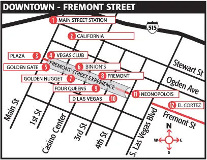
Downtown is the “original” Vegas, located about 10–15 minutes north of the Strip by car. The center of the action is the Fremont Street Experience, a five-block pedestrian mall covered by a massive LED canopy.
- Fremont East: This is where the locals hang out. It’s full of trendy bars, the Container Park, and some of the best street food in the city.
- Arts District (18b): Located halfway between the Strip and Fremont, this is the cultural soul of the city. Expect breweries, vintage shops, and incredible murals.
Direct Answer: Downtown Las Vegas offers a more concentrated, walkable experience compared to the Strip. Key highlights include the Fremont Street Experience light shows and the historic Neon Museum, where the city’s iconic old signs go to retire. It is roughly 4 miles north of the center Strip.
Transportation: Mapping Out Your Rides
You have several ways to get around the map, and your choice depends on your budget and how much time you have.
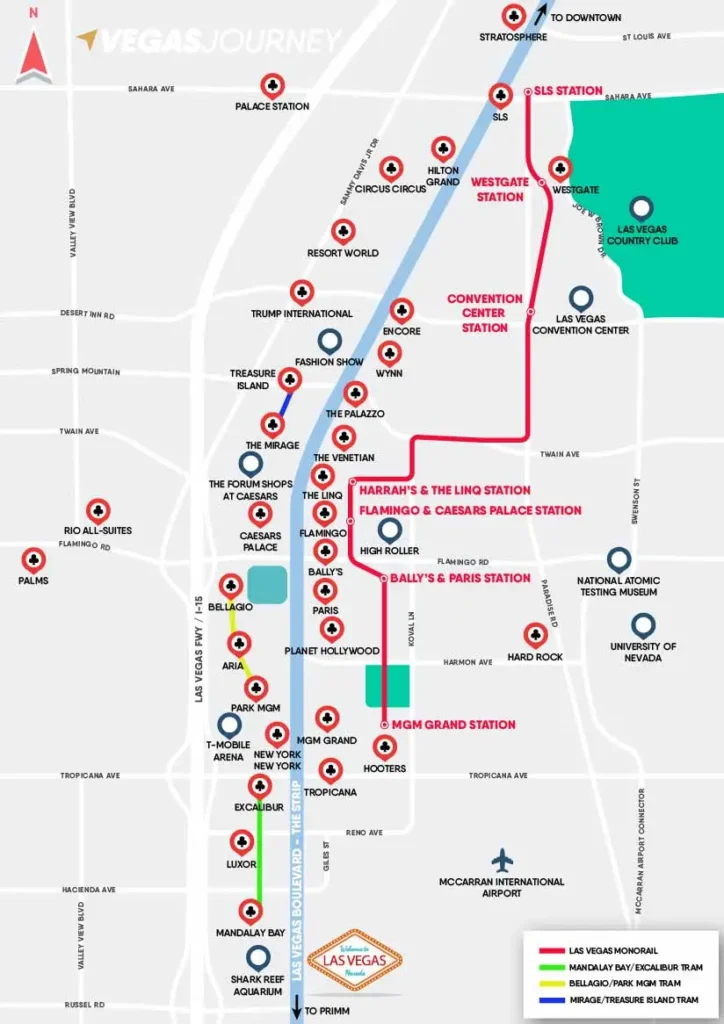
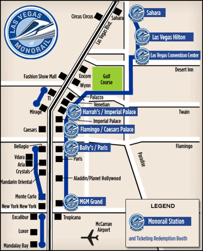
- The Las Vegas Monorail: Runs along the east side of the Strip (behind the hotels) from MGM Grand to SAHARA. Great for skipping traffic.
- Free Trams: There are three free trams on the West side:
- Mandalay Bay – Luxor – Excalibur
- Aria – Bellagio – Vdara
- Treasure Island – The Mirage (Note: Subject to change with the Hard Rock transition).
- The Vegas Loop: The Tesla tunnel system by Elon Musk. It connects Resorts World to the Las Vegas Convention Center, with expansion toward the Strip and Downtown ongoing.
Summary & Final Helpful Tip
The Las Vegas Map Guide boils down to one rule: don’t trust your eyes. Everything in Vegas is bigger than it looks. A “short” walk between resorts often involves multiple pedestrian bridges and escalators.
Our Best Helpful Tip: Use the Free Trams whenever possible! They save your feet and run every few minutes. If you’re at the Bellagio and want to get to Park MGM, the tram is a lifesaver that keeps you in the air conditioning for most of the journey.
❓ FAQ: Las Vegas Map Guide
Can I walk from the Strip to the “Welcome to Las Vegas” sign?
You can, but it’s a long trek with very little shade. If you are at Mandalay Bay, it’s about a 15–20 minute walk. In the summer heat, we have found it’s much better to take a quick Uber.
Is “Old Vegas” the same as Downtown?
Yes. “Old Vegas” refers to the Fremont Street area in Downtown. It’s where the city’s first casinos like the Golden Nugget were built.
How far is the Sphere from the main Strip?
The Sphere is located behind the Venetian. While you can see it from the sidewalk, walking to the entrance takes about 15–20 minutes through the Venetian Expo tunnels.
Keep Reading:
- Best Airport to Fly Into for Las Vegas: Save Time & Money at LAS
- What Are the Las Vegas Age Limits? Gambling, Hotels & Curfew
- Las Vegas Airport Guide (LAS): Terminals, Uber & Taxis
- How Much to Tip in Las Vegas
- How to Plan a Trip to Las Vegas: Easy Step-by-Step Guide
- Is Las Vegas Worth Visiting? Full Travel Verdict